Maps
DesBarres (1780)
DesBarres (1780)
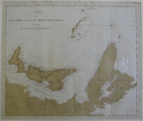
Title: A Chart of Cape Breton and St. John’s Islands, &c. in the Gulph of St. Lawrence
Cartographer: J.F.W. Des Barres
Image size: 23 1/2 x 28” (59.7 x 71.1 cm) to outer neat line
Description: Chart liberated from an edition of the Atlantic Neptune. This state of the map is early and not listed in Kershaw’s standard reference, Early Printed Maps of Canada. Shows soundings, but only one place name (Port Hood) for all of Cape Breton. Early hand-color.
Colonel Joseph Frederick Wallet DesBarres (1721–1824) was a cartographer who served in the Seven Years’ War, as the aide-de-camp to General James Wolfe. DesBarres went on to serve as the Lieutenant-Governor of Cape Breton, and later as Lieutenant-Governor of Prince Edward Island. DesBarres also created the monumental four volume Atlantic Neptune, which was the most important collection of maps, charts and views of North America published in the 18th century. Colonel DesBarres is buried with his wife in the crypt of St. George’s (Round) Church, Halifax.
Source: Wikipedia